
 No. Rek. 1781-2705-18 @Dodi Hidayat |
 No. Rek. 118-000-7389-603 @Dodi Hidayat |
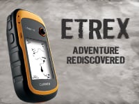
eTrex® 10 | Garmin - GPS GARMIN ETREX 10

Produk yang ditawarkan :
Total Station. Waterpass. Theodolite Digital. Hammer test. Anemometer.Anggle Meter.Lux Meter. Sound Level. Kompas. Clinometer. Weather Station. GPS Geodetik. GPS Map. GPS Echosounder. Abney Level. Rain Gauge / Curah Hujan. Sirine. Levelling Laser. Fusion Splicer. Digipas. Laser Meter.Meteran. Waterpass Digital. Coating Thiknes. Thermometer. Thermo hygrometer. SIRINE.Kompas, Clinometer, Abney Level, Flowacth, Laser Range Finde,Fusion Splicer, Sand Cone test, DCP, Palu geologi, Loupe, Batre dan Charger, Tripod, Prisma Polygon, Single Prisma, mini Prisma, Bak Ukur, Range Pole, Kabel Data,DO meter, FLIR, Dll masih banyak lagi pokonya.
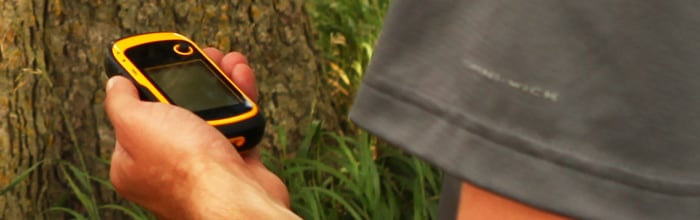
Rugged Handheld GPS with Enhanced Capabilities
- Worldwide basemap
- 2.2" monochrome display, easy to read in any light
- GPS and GLONASS satellites for faster positioning
- Paperless geocaching
- 25-hour battery life with 2 AA batteries
Only
Garmin could make the eTrex better. The new eTrex 10 retains the core
functionality, rugged construction, affordability and long battery life
that made eTrex the most dependable GPS device available. We improved
the user interface and added a worldwide basemap, paperless geocaching
and added support for spine mounting accessories. You’ll recognize the
name. You’ll recognize the quality. But the eTrex 10 is an entirely new
device – a device that only Garmin could offer.
See The Way
eTrex 10 has an enhanced 2.2 in monochrome display that’s easy to read in any lighting situation. Both durable and waterproof, eTrex 10 is built to withstand the elements. Its easy-to-use interface means you’ll spend more time enjoying the outdoors and less time searching for information. eTrex 10 features the legendary toughness that’s built to withstand the elements – be it dust, dirt, humidity or water, none of which are a match for this storied navigator.Find Fun
eTrex 10 supports geocaching GPX files for downloading geocaches and details straight to your unit. Visit OpenCaching.com to start your geocaching adventure. By going paperless, you're not only helping the environment but also improving efficiency. eTrex 10 stores and displays key information, including location, terrain, difficulty, hints and descriptions, which means no more manually entering coordinates and paper print outs. Simply upload the GPX file to your unit and start hunting for caches.Keep Your Fix
With its high-sensitivity, WAAS-enabled GPS receiver and HotFix® satellite prediction, eTrex 10 locates your position quickly and precisely and maintains its GPS location even in heavy cover and deep canyons. The advantage is clear — whether you’re in deep woods or just near tall buildings and trees, you can count on eTrex 10 to help you find your way when you need it the most.Go Global
The new eTrex series is the first-ever consumer-grade receivers that can track both GPS and GLONASS satellites simultaneously. GLONASS is a system developed by the Russian Federation that will be fully operational in 2012. When using GLONASS satellites, the time it takes for the receiver to “lock on” to a position is (on average) approximately 20 percent faster than using GPS. And when using both GPS and GLONASS, the receiver has the ability to lock on to 24 more satellites than using GPS alone.General
| Physical dimensions | 5.4 x 10.3 x 3.3 cm |
|---|---|
| Weight | 141.7 g with batteries |
| Water rating | IPX7 |
| Battery type | 2 AA batteries (not included); NiMH or Lithium recommended |
| Display type | transflective, monochrome |
| Display size | 3.6 x 4.3 cm; 5.6 cm diag |
| Display resolution | 128 x 160 pixels |
| Battery life | 25 hours |
| High-sensitivity receiver | |
| Interface | USB |
Maps & Memory |
|
| Basemap | |
|---|---|
| Custom POIs (ability to add additional points of interest) | |
| Waypoints/favorites/locations | 1000 |
| Routes | 50 |
| Track log | 10,000 points, 100 saved tracks |
Outdoor Recreation Features |
|
| Area calculation | |
|---|---|
| Geocaching-friendly | Yes (Paperless) |
| Hunt/fish calendar | |
| Sun and moon information | |
Garmin Connect™ |
|
| Garmin Connect™ compatible (online community where you analyze, categorize and share data) | |
|---|---|
No. Rek. 1781-2705-18 @Dodi Hidayat |
No. Rek. 118-000-7389-603 @Dodi Hidayat |
Social Plugin